LiveView: Agriculture GPS Tracking

Pipe AG’s LiveView agriculture GPS tracking delivers real-time visibility into every machine, operator, and movement across your operation. Designed to eliminate guesswork and improve coordination, LiveView provides a complete, always-updated picture of what is happening in the field and on the road. With intuitive visuals, detailed machine data, and seamless integration across all equipment brands, LiveView empowers crews to make faster decisions and keep operations running efficiently.

Equipment Insights at a Glance

On the left side of the LiveView interface, users have access to a detailed list of all equipment in the crew. This list provides critical operational data for each machine, allowing managers and operators to monitor performance instantly.
Key data points include:

  • Equipment speed
  • Grain cart weight
  • Truck status
  • Combine fill levels accurate within 1%

This level of detail ensures that every decision is based on accurate, up-to-date information. Managers no longer need to rely on radio updates or manual reporting to understand what is happening in the field.

Users can tap on any machine in the list to instantly zoom in and target that specific piece of equipment on the map. This feature allows for quick identification and response when attention is needed.

A Complete Real-Time Operational View

LiveView agriculture GPS tracking is built around a dual-interface system that provides both detailed data and visual mapping at the same time. This structure ensures that users can quickly understand the status of their entire operation without switching between screens or tools. On one side, users see a full list of equipment and key performance data. On the other, a live satellite map displays every machine in motion. Together, these elements create a powerful, unified view that supports real-time decision-making.

Real-Time Satellite Mapping

On the right side of the interface, LiveView displays a satellite map with all equipment shown in real time. This visual representation gives users immediate awareness of machine locations, movement patterns, and field activity. The satellite view provides context that goes beyond simple coordinates. Users can see how equipment interacts with field boundaries, roads, and terrain. This clarity improves coordination and helps prevent inefficiencies such as overlap or unnecessary travel. LiveView ensures that every movement is visible and understandable, giving managers confidence in how their operation is progressing.

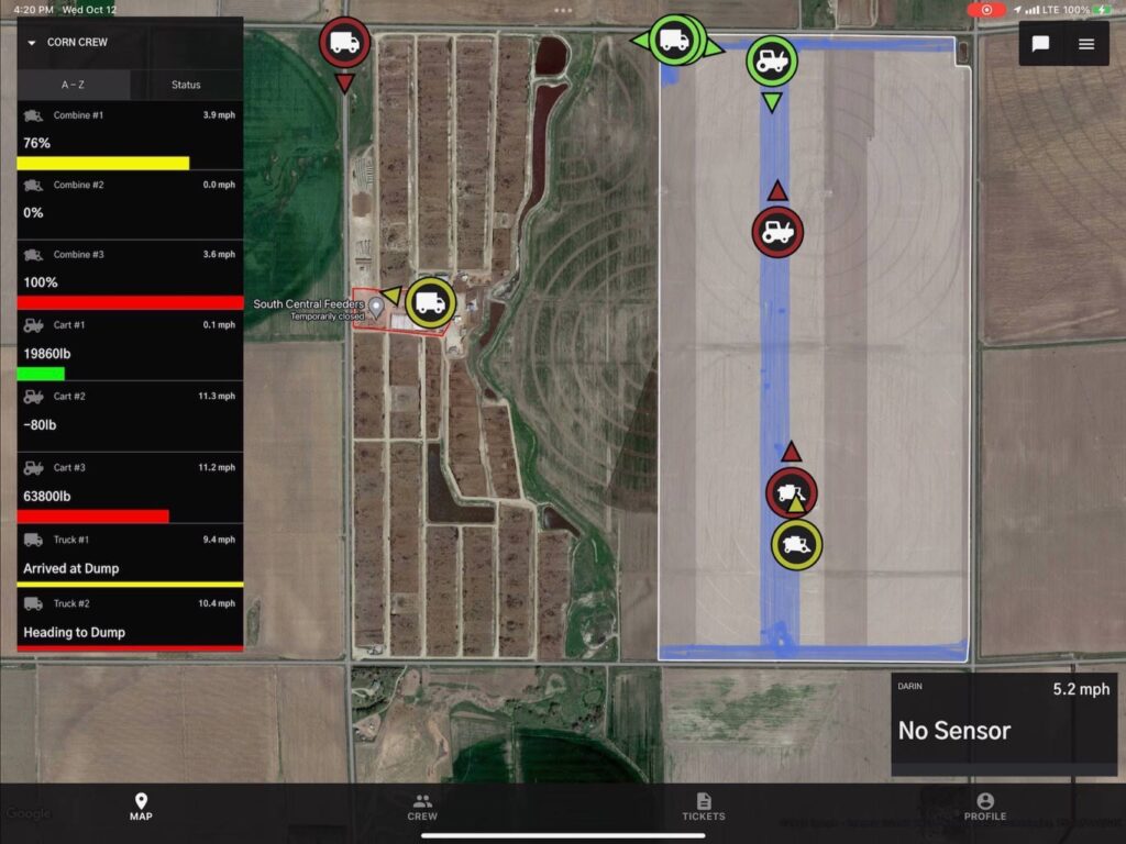
Shared Coverage and Compaction Visibility

LiveView agriculture GPS tracking goes beyond basic location tracking by incorporating shared operational data across the entire crew. Every user can view shared combine coverage and grain cart compaction maps directly on the satellite image.
This shared visibility allows teams to:

  • See which areas have already been harvested
  • Avoid overlap between machines
  • Identify high-compaction zones
  • Coordinate equipment movement more effectively

Because this information is shared across all devices, every operator works from the same data. This consistency improves efficiency and reduces the need for constant communication.

Instantly Locate Every Truck

One of the most common questions during harvest is simple but critical: where are the trucks? LiveView answers this instantly. By pressing the crew view icon on the map, the system automatically zooms out to display the exact location of every truck in real time. This feature eliminates the need for phone calls or radio check-ins and provides immediate clarity. Managers can quickly assess: Which trucks are in the field, which are on the road, and which are at the dumpsite. This visibility supports better planning and ensures that equipment is always where it needs to be.

Color-Coded Status for Instant Understanding

LiveView uses a color-coded system to indicate the status of each piece of equipment, making it easy to understand operations at a glance. Red indicates trucks that are loaded and traveling from the field to the dumpsite, Yellow indicates trucks currently at the dumpsite, and Green indicates trucks in the field. This simple visual system allows users to interpret complex logistics instantly. Without reading detailed data, managers can see the flow of trucks and identify potential delays or imbalances.

Built for Accuracy and Reliability

Pipe AG designs and builds its own sensors to ensure consistent and reliable performance. These sensors are engineered specifically for agricultural environments, providing accurate data without the need for constant maintenance.

Benefits of Pipe AG sensor technology include:

  • High accuracy for weight and fill measurements
  • Reliable performance in demanding conditions
  • Minimal maintenance requirements
  • Seamless integration with LiveView features

This focus on reliability ensures that users can trust the data they see and make decisions with confidence.

Automatic ETA with No Driver Input

Efficiency depends on timing, and LiveView provides automated timing insights without requiring input from drivers. When a truck leaves the dumpsite, the system automatically calculates and displays an estimated time of arrival back to the field. This ETA feature helps managers plan ahead and coordinate equipment more effectively. Combines and grain carts can prepare for incoming trucks, reducing wait times and improving overall workflow. Because the system operates automatically, drivers can stay focused on their tasks without needing to enter data manually.

Fast Installation Across All Equipment Brands

Pipe AG’s LiveView agriculture GPS tracking is designed for easy deployment across any operation. The system uses plug-and-play wiring harnesses that are compatible with all major equipment brands. Installation is quick and straightforward, typically taking less than 15 minutes per machine. This allows farms to implement the system without downtime or complicated setup processes. Advantages of plug-and-play installation include: Compatibility with mixed equipment fleets, minimal disruption to operations, rapid system rollout, and easy scalability as operations grow. This flexibility makes LiveView accessible to farms of all sizes and configurations.

PIPE AG’s LIVE-VIEW Agriculture GPS Tracking features have two main elements of information. On the left side, you have a list of all equipment in your crew. Operators can see their speed, grain cart weight, truck status and even how full each combine is within 1%. By tapping on any of these machines, you can zoom in or “target” that specific machine.


On the right you have a satellite map with all of your machines in real-time.

Everyone in the crew can see shared combine coverage, or a grain cart compaction map on a satellite image regardless of the equipment brand.


Do you ever ask yourself “where are the trucks at?” Simply press the crew view icon on the map and the screen automatically zooms out to show you every trucks exact location on the road in real-time.


All equipment is color coordinated to match its “status”. Trucks in red are loaded and headed from the field to the dumpsite. Yellow indicates that they are at the dumpsite and as soon as they leave the dumpsite, an ETA is automatically displayed of when they will be back to the field, with zero input from the driver. Green signifies that the truck is at the field.


We design and build our own sensors for problem-free and maintenance free operation. PIPE AG’s wiring harnesses are “plug and play” and are compatible with all equipment brands that install in less than 15 minutes.A

Supporting Better Decision-Making in Real Time

LiveView agriculture GPS tracking provides the information needed to make fast, informed decisions. With real-time data and clear visuals, managers can respond immediately to changing conditions in the field. Examples of improved decision-making include: Redirecting trucks based on location and status, adjusting combine operations based on fill levels, identifying and resolving bottlenecks quickly, and coordinating grain carts with incoming trucks. By having all relevant data in one place, users can act with confidence and keep operations running smoothly.

Enhancing Efficiency and Reducing Downtime

Efficiency is critical during busy seasons, and LiveView helps eliminate the delays that slow operations down. By providing full visibility into equipment status and movement, the system reduces idle time and improves coordination. Farms benefit from: Faster turnaround times for trucks, better alignment between combines and grain carts, reduced waiting and downtime, and improved overall productivity. These efficiency gains translate directly into better performance and lower operational costs.

The Pipe AG Advantage

Pipe AG’s LiveView agriculture GPS tracking delivers unmatched visibility, accuracy, and ease of use for modern farming operations. By combining detailed equipment data with real-time satellite mapping, the system provides a complete view of the operation at all times.

With shared coverage insights, automatic ETAs, color-coded status indicators, and seamless integration across all equipment brands, LiveView transforms how farms manage logistics and coordination.

Pipe AG makes it possible to answer critical questions instantly, respond to changes quickly, and operate with confidence. LiveView is more than tracking. It is a smarter way to manage your entire operation in real time.